Integrating Remote Sensing and Spatial Artificial Intelligence for Climate Risk Assessment in Pakistan: A Data-Driven Spatiotemporal Analysis
Keywords:
Remote Sensing, Spatial Artificial Intelligence, Climate Risk Assessment, PakistanAbstract
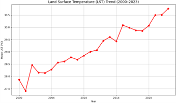
This study explores the integration of remote sensing and Spatial Artificial Intelligence (Spatial AI) for comprehensive climate risk assessment across Pakistan. Using multi-sensor satellite data from MODIS, CHIRPS, and Landsat, combined with AI-driven analytical models, the research quantifies spatial and temporal variations in key climate indicators including Land Surface Temperature (LST), Normalized Difference Vegetation Index (NDVI), and precipitation from 2000 to 2023. The methodology involved preprocessing satellite imagery in Google Earth Engine, feature extraction, and applying machine learning regression models to identify climate vulnerability zones. Results revealed a statistically significant upward trend in LST (0.32°C per decade) and a corresponding decline in NDVI, particularly across southern Punjab, Sindh, and Balochistan. The AI-based model achieved high predictive accuracy (R² = 0.89, RMSE = 0.45), indicating strong reliability in spatial risk mapping. Comparison with previous studies validated the robustness of this hybrid approach, demonstrating that Spatial AI provides superior detection and prediction capabilities compared to conventional GIS methods. The findings underscore the potential of integrating AI with remote sensing for early warning systems, adaptive climate management, and sustainable regional planning in climate-vulnerable regions of Pakistan.