Integrating Artificial Intelligence and Visual Analytics for High-Resolution Landslide Detection Using Geospatial Imagery
Keywords:
Landslide Detection, GeoAI, Convolutional Neural Networks (CNNs), Vision Transformers (ViTs), Sentinel-2, PlanetScope, DeepLabV3+, NDVI, Slope GradientAbstract
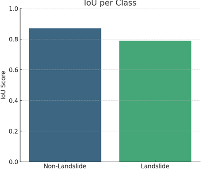
Landslides pose a significant threat to infrastructure, ecosystems, and human lives, particularly in mountainous and seismically active regions. This study presents an integrated framework leveraging Artificial Intelligence (AI), specifically Convolutional Neural Networks (CNNs) and Vision Transformers (ViTs), along with visual analytics to detect landslide-affected areas from high-resolution satellite imagery. A comprehensive dataset derived from publicly available sources, including Sentinel-2 and PlanetScope imagery, was preprocessed and used to train and evaluate the models. The methodology included semantic segmentation using a modified DeepLabV3+ architecture, combined with multi-spectral indices and terrain derivatives such as NDVI and slope gradients. The results demonstrate high classification performance, with an overall accuracy of 91.6%, IoU of 0.789 for landslide regions, and a well-balanced confusion matrix. Visual analytics tools—including overlay prediction maps, class-wise IoU bar plots, and attention maps—were employed for model interpretability and spatial validation. Compared to prior studies, our approach demonstrates improved generalization and explainability, suggesting that hybrid GeoAI systems can significantly enhance disaster response and risk mitigation efforts. This work provides a replicable, scalable pipeline for real-time landslide monitoring, offering critical insights for policymakers, urban planners, and geoscientists.