Integrating Geospatial and Machine Learning Approaches for Flood Risk Assessment and Disaster Management: A Case Study of Sheikhupura District, Pakistan (2022–2024)
Keywords:
Floods, Natural Hazards, Urbanization, Climate Variability, Drainage Infrastructure, Geographic Information Systems (GIS)Abstract
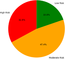
Floods remain one of the most destructive natural hazards worldwide, posing severe threats to human life, infrastructure, and livelihoods. In Pakistan, rapid urbanization, climate variability, and poor drainage infrastructure have intensified flood vulnerability, particularly in districts like Sheikhupura. This study evaluates the effectiveness of integrating Geographic Information Systems (GIS), remote sensing, and machine learning (ML) techniques for flood risk assessment and disaster management in Sheikhupura from 2022 to 2024. Multi-source datasets, including Sentinel-1 SAR, Sentinel-2 imagery, digital elevation models, meteorological records, hydrological data, and socio-economic information, were processed and analyzed using supervised classification, multi-criteria decision analysis (MCDA), and machine learning models (Random Forest and Support Vector Machine). Flood susceptibility mapping revealed that 32.8% of the district lies in high-risk zones, 47.4% in moderate-risk zones, and 19.8% in low-risk areas. Random Forest outperformed SVM with an accuracy of 89% and an AUC of 0.92, demonstrating superior predictive capability. Temporal analysis indicated that 2023 experienced the most severe flood events, causing economic losses exceeding PKR 3 billion, primarily affecting agriculture, infrastructure, and health sectors. The findings underscore the critical need for targeted flood preparedness, early warning systems, and climate-resilient planning. This study provides actionable insights for local authorities and contributes to the broader understanding of data-driven flood management strategies in South Asia.