GIS-Based Multi-Criteria Decision Analysis for Optimal Emergency Assembly Place Selection in Urban Areas
Keywords:
Emergency Assembly Places, GIS, Multi-Criteria Decision-Making, BWM, TOPSIS, Disaster Management, Urban PlanningAbstract
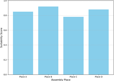
Effective disaster management requires the identification of suitable emergency assembly places that ensure public safety, accessibility, and adequate capacity. This study presents a comprehensive framework integrating Geographic Information Systems (GIS) and Multi-Criteria Decision-Making (MCDM) techniques to evaluate and prioritize potential assembly locations. The Best-Worst Method (BWM) was employed to assign weights to relevant criteria, including accessibility, hazard exposure, population capacity, and land suitability. Subsequently, the Technique for Order of Preference by Similarity to Ideal Solution (TOPSIS) was applied to rank alternatives. Spatial analysis revealed that Place B achieved the highest suitability score due to its optimal balance of accessibility, safety, and capacity, while Place C exhibited lower suitability owing to limited accessibility and vulnerability to hazards. The results demonstrate the effectiveness of combining GIS and MCDM methods in supporting data-driven decision-making for disaster preparedness. The methodology provides urban planners and emergency managers with a replicable framework to enhance evacuation planning, minimize risks, and improve community resilience.