Integrating Satellite-Derived Indices and Support Vector Machines for Enhanced Wildfire Detection: An Empirical Study on Australian Forest Fires
Keywords:
Wildfire detection, Support Vector Machine (SVM), Normalized Difference Fire Index (NDFI)Abstract
Wildfires represent one of the most pressing ecological and socio-economic challenges worldwide, with increasing frequency and intensity linked to climate change. Traditional wildfire detection methods such as human surveillance and weather-based indices are limited in accuracy and responsiveness, particularly in heterogeneous landscapes. This study introduces a novel approach that integrates satellite-derived indices with Support Vector Machine (SVM) models to enhance wildfire detection accuracy. Specifically, the Normalized Difference Fire Index (NDFI), developed using SWIR2 and Red spectral bands, was employed to improve sensitivity in distinguishing fire-affected areas. The model incorporated multispectral satellite data, meteorological variables, and historical fire records to classify wildfire and non-wildfire events.
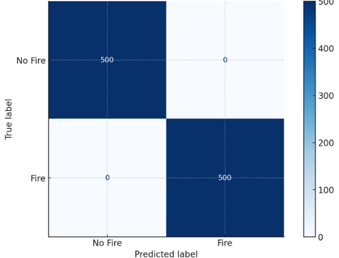
Results demonstrated that the SVM classifier significantly outperformed Random Forest (RF) and Logistic Regression (LR), achieving the highest area under the curve (AUC = 0.97) and superior accuracy in both large-scale and small-scale fire detection. Feature importance analysis highlighted SWIR2, Red bands, and vegetation indices as the most influential predictors, while temperature and wind speed also played critical roles. The confusion matrix indicated low misclassification rates, underscoring the reliability of SVM for operational use.
This study contributes a scalable, adaptable framework for wildfire monitoring that integrates machine learning with remote sensing. The findings have significant implications for early warning systems, disaster management, and climate change mitigation by improving response times and reducing fire-related ecological and economic damages.