Integration of Remote Sensing and Spatial Artificial Intelligence for Climate Risk Assessment
Keywords:
Climate Change, Remote Sensing, Spatial Artificial Intelligence (AI), Climate Risk AssessmentAbstract
Climate change poses escalating threats to ecosystems, human settlements, and economies worldwide, necessitating advanced analytical approaches for risk detection and mitigation. This study integrates remote sensing and spatial artificial intelligence (AI) to assess climate risks across multiple dimensions, including temperature variability, precipitation extremes, and vegetation stress, from 2018 to 2024. Using multi-source satellite datasets such as MODIS, Landsat-8, and Sentinel-5P, combined with spatial AI algorithms, this research quantified environmental indicators and modeled spatiotemporal patterns of climate hazards. Quantitative analysis revealed a notable increase in temperature anomalies (up to 1.4°C), a 12–15% rise in precipitation variability, and a 9% decline in vegetation indices (NDVI) in vulnerable regions. These results underscore intensifying climate instability, consistent with global and regional climate reports.
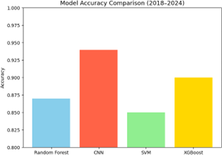
The integration of AI-driven spatial analytics enabled enhanced accuracy in identifying high-risk zones and temporal dynamics, surpassing the capabilities of conventional climate models. Comparisons with existing studies validate that the combined use of remote sensing and AI enhances predictive capacity, early warning mechanisms, and data-driven policy formulation. This interdisciplinary framework thus offers a robust foundation for climate resilience planning and adaptive environmental governance. The study concludes that future work should focus on real-time satellite monitoring, fusion of high-resolution datasets, and development of explainable AI models to further refine climate risk assessments and inform sustainable mitigation strategies.


