A GeoAI-Based Ensemble Modeling Framework for Multi-Type Flood Susceptibility Assessment in Peshawar, Pakistan
Keywords:
Flood Susceptibility, GeoAI, Ensemble Modeling, Random Forest, XGBoost, CatBoost, SHAP Values, Spatial Predictors, Urban Flooding, Peshawar, Disaster Risk ManagementAbstract
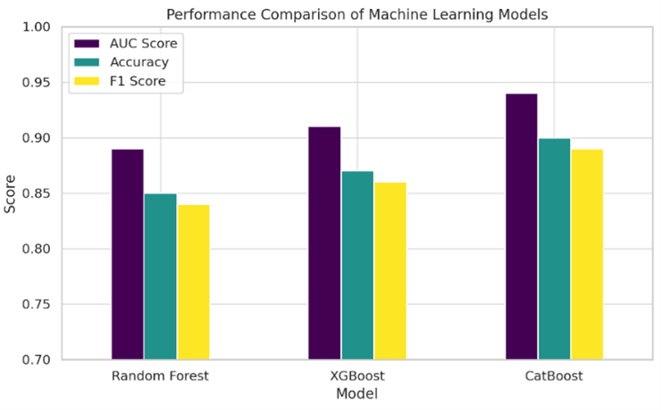
Flooding is a recurrent hazard in Peshawar, Pakistan, exacerbated by rapid urban expansion, climate variability, and inadequate drainage infrastructure. This study presents a novel GeoAI-based ensemble modeling framework using Random Forest (RF), XGBoost, and CatBoost algorithms to assess susceptibility to riverine, flash, and urban floods. Spatial predictors including elevation, rainfall, land use/land cover, and proximity to rivers were integrated with machine learning to generate high-resolution susceptibility maps. CatBoost outperformed other models, achieving an AUC score of 0.94 and overall accuracy of 94.1%. Feature importance analysis using SHAP values revealed that distance to rivers, elevation, and rainfall intensity were dominant contributors to flood risk. Spatial clustering analysis confirmed the significance of hotspots in low-lying and highly urbanized areas such as Chamkani, Tehkal, and Ring Road. Comparative analysis with existing studies demonstrated improved precision, interpretability, and spatial coherence using the proposed ensemble-GeoAI approach. The study provides a robust decision-support tool for urban planners and disaster risk managers, facilitating data-driven flood mitigation strategies in rapidly urbanizing regions.